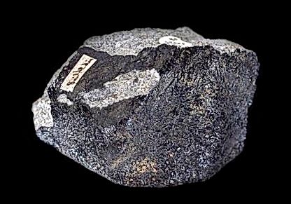
Meteorites fall if you’ll pardon the pun into one of three basic categories: irons, stony-irons, and stones. Further distinctions are made within each of these classifications, according to their petrological and chemical compositions. Within the stone category, there are chondrites and achondrites. Both types have a number of subgroups, the length and depth of which are slightly beyond the scope of this article. Suffice it to say that the chondrites are known for their spherical, millimetre- and submillimetre-sized particles referred to as chondrules. The achondrites on the other hand, contain no visible chondrules and are in fact “differentiated” meteorites that formed from primary, primitive material through a melting process. Found within this group are the SNC meteorites, which are widely believed to have originated on Mars.
Whereas stone meteorites usually consist of less than 27% metal by weight, iron meteorites exceed the 90% level. In contrast with members of the stone family and their crustal origins, the irons are thought to have come from the core of their particular parent body. Interestingly, iron meteorites do have something in common with the achondrites in that they too were formed through a melting and recrystallization process. Keeping with the K.I.S.S. formula, iron meteorites come under one of three classifications: Octahedrites, with their familiar Widmanstatten structure; hexahedrites, with their Neumann lines; and finally, the ataxites, which do not have any visible structure.
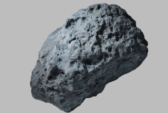
If the overall supply of stone and iron meteorites could be described as plentiful, the same cannot be said for the third type, known as the stony-irons. Considered very rare, they represent less than three percent of the known meteorites. While slight variations exist, in actuality only two groups have a reasonable number of specimens. Pallasites, the most common of the stony-irons, are probably the most spectacular of meteorite specimens, consisting of olivine crystals completely ensconced by a continuous network of nickel-iron. Further, their nickel-iron content has an octahedrite structure and composition, displaying the noted Widmanstatten pattern when etched. Mesosiderites, on the other hand, differ from pallasites in terms of inner structure. Here the nickel-iron content is often ragged and set within a stony matrix. Additionally, while pallasites are relatively unaltered rocks from the parent body’s mantle, the mesosiderites are broken mantle rock reassembled with lighter silica rock, and described as a polymict breccia.
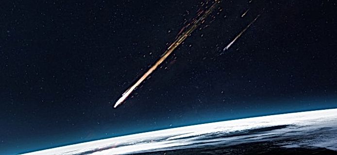
Meteorites can be divided into chondrites and the “rest.” The most primitive chondrites are interpreted to represent the chemical composition of the primordial Solar Nebula from which the Solar System originally formed. Chondritic material in the primordial Solar Nebula accreted together to form larger lumps that we now call “asteroids”, which continued to accrete to form the rocky planets that form the inner Solar System, including planet Earth. How well do the “rest” of the meteorites fit this story of planetary and asteroidal evolution?
Achondrites
The “rest” of the meteorites are called achondrites (not chondrites), traditionally divided into stones, irons and stony-irons. Stones are what we on Earth would simply call rocks. The general idea is that they were originally made of chondrite that heated up and melted; but how does this kind of thing happen? Heat is produced in rocks by radioactive elements such as uranium, thorium and potassium that decay into things like lead and argon. In doing so they give off heat, just like a nuclear reactor, and things get hotter.
Melting and Crystallization
Geologically, melting is a very strange process. Ice is solid water: when it melts, we get liquid water, but rocks don’t behave this way. Venus and Mars are differentiated planets with crusts made from volcanic basalt lavas, similar to the composition of the ocean floors on Earth. Where does basalt come from? Basalt is made of two minerals called feldspar and pyroxene, and it’s the product of the partial melting of a third mineral called olivine. Partial melting means you don’t melt all of the olivine, just part of it. In other words, if you partially melt one thing, the melt you get is another composition entirely. However, the geology of magmas or melts is just as weird when it comes time for them to cool down and crystallize. If a magma cools slowly, instead of forming one kind of rock it forms a whole family of different rocks at different temperatures. What all this means is that if you start with one mineral and you melt it progressively, then let the melt cool progressively, you end up with a variety of rocks that range from basalt to granite! This is how chondrites differentiate into the host of different rocks that the rocky planets are made of.
Differentiated Bodies
What does the average differentiated rocky planet look like? It has an thin outer crust made of basalt, and a relatively small iron-nickel sulphide core. In between the two is a very thick mantle that’s mostly made of the mineral olivine. The bottom line is that theory tells us that homogeneous chondrite bodies heat up and melt, then cool and crystallise to form differentiated planets or large asteroids that are made of a variety of different rocks.
Stones
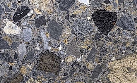
According to this story, some meteorites should look like planetary crust: these are called eucrites, and they are simply basalts. Another kind is called diogenite, and these have the same mineral composition as the rocks that form the top of the Earth’s mantle, just beneath its crust. Another kind, called howardites are mixtures of eucrite and diogenite that form when large impacts occur on differentiated asteroids or planets that breach the crust through to the upper mantle, resulting in a mixture of fragments of the crust and mantle rocks (breccia). These meteorites support the idea of differentiation of initially chondritic bodies during the accretionary phase of the evolution of the Solar System.
Irons and Stony Irons
Iron meteorites are made of Ni-Fe alloys, which is what planetary geologists think most rocky planets have at their cores. The beautiful Pallasites, probably the best known stony irons, are mixtures of olivine and Fe-Ni alloys that represent a mixed melt derived from the lowermost part of a differentiated
Variations in Differentiated Planets
The presence of irons in the meteorite population that falls to Earth requires the breakup of large differentiated planetary or asteroidal bodies. However, according to the differentiated planet model, an olivine-rich mantle is more voluminous than either the crust or the core. So, where are the meteorites from the differentiated mantles that should be made of the mineral olivine? Proportionally, these should form the majority of meteorites according to the differentiation story. There are some, called brachinites, but they are very rare, The absence of abundant brachinites is probably the greatest conundrum facing meteoriticists today!
Problems with Chondrite Theory?
Chondrules are classically interpreted as interplanetary dust-balls that were flash-melted and rapidly frozen during the development of the very early stages of the primordial Solar Nebula. However, a very common kind of chondrule is porphyritic, which means that it contains large, well formed crystals of olivine or pyroxene that represent crystals that had formed prior to the flash-melting event that formed the chondrules themselves. Geologically, the problem is that well formed crystals of olivine and pyroxene only form in large volumes of melt that cool very slowly, thereby giving the crystals time to grow to a large size. The only place this can occur is inside relatively large asteroids or planetary bodies. The fact that these crystals turn up inside chondrules means that some chondrite meteorites are not all that
Impact Breccias
Chondrules were still forming in the Solar Nebula after relatively large asteroids had already accreted and begun to melt internally. Furthermore, how were the well formed crystals extracted from differentiated asteroids? Impacts would have shattered the crystals because of the tremendous force involved, yet this does not appear to be the case. Frankly, I’m stumped.
Another problematic observation is the presence of calcium aluminum inclusions that occur in carbonaceous chondrites. Many of these inclusions are pretty unremarkable, like pyroxenes and feldspars, but others include perovskite. On Earth, the only place we find pervoskite is in lumps brought up in volcanic pipes from deep within the Earth’s mantle. The problem here is that carbonaceous chondrites are the most primitive kind of meteorite and, in theory, they’ve never been involved in the differentiation of large asteroids or rocky planets. So where did the perovskite come from? Quite honestly, no-one knows!
Asteroids
Ceres is the largest and first asteroid discovered, but it is made of primitive carbonaceous chondrite. So much for large asteroids heating up, melting and differentiating! Vesta, on the other hand, the second largest asteroid, has a eucritic or basaltic crust and appears to be the type example of a differentiated asteroid with a crust, and mantle, and possibly a core. Pallas, however, is not made of pallasite, but is composed of carbonaceous chondrite! It turns out that the asteroid is named after a classical Greek, while the meteorite is named after a certain Mr Pallas1